| HideElements | ||||||||||||||||||||||||||||||||||
|---|---|---|---|---|---|---|---|---|---|---|---|---|---|---|---|---|---|---|---|---|---|---|---|---|---|---|---|---|---|---|---|---|---|---|
|
| Background Color | ||||||||||||
|---|---|---|---|---|---|---|---|---|---|---|---|---|
| ||||||||||||
|
MapTac™ is primarily a briefing tool used to display a variety of graphics and images. This standard WebEOC plugin replaces or augments static, paper-based maps and magnetic light boards. MapTac allows authorized users to access an image of a static map, dispersion model, digital photo, and more from any map/GIS source or digital camera and, using a web browser, instantly share the tactical scene with other users.
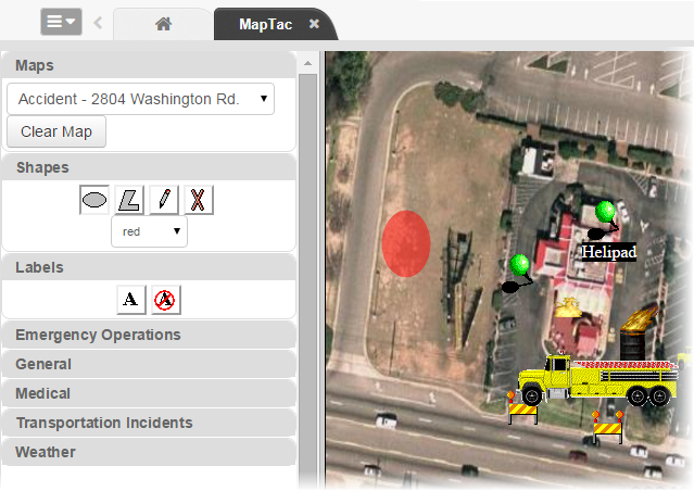
MapTac can use images from any GIS or mapping system to produce a static image file, such as a JPEG, GIF, or BMP. Existing web-based mapping resources available on the Internet can also be used to plot an address in order to create an image file that can then be saved to MapTac and annotated as necessary using the icon palette and drawing tools. MapTac also allows responders at geographically separate locations to view and, depending on user privileges, update images in real time.
Users with appropriate permissions can draw shapes on the image and add markers such as push pins, fire trucks, and road blocks. Labels can be added and edited at any time. Administrators can also add a URL to an icon that allows users to access related information by clicking the icon attached to the image file in MapTac.
MapTac Components
The headers in the MapTac tool pane can be expanded and collapsed by clicking the related tab. The major components are:
Maps – Drop-down list of maps/images; contains a Clear Map button.
Shapes – Ellipse, polygon, and free-hand drawing tools;contains a delete button and a shape color drop-down list.
Labels – Contains add and remove label buttons.
Marker tabs – Contains categorized markers.
Map view – Pane that houses a printer icon.
| Panel | ||||||||
|---|---|---|---|---|---|---|---|---|
| ||||||||