![]()
Being able to visualize crisis information data on a map is essential to making good decisions during an emergency. Maps, an integrated mapping solution that comes standard with any WebEOC Core, Professional, or Enterprise instance, helps with this visualization by providing organizations the tools necessary to create a dynamic, geographically-based common operating picture through a map-based interface.
Access Maps from the Control Panel
The Maps section of the control panel contains maps created by your administrator for incidents, training events, functional areas, specific boards, and so forth. The maps visible to you are managed by your administrator; thus, you may see different maps or have different permissions than other users in WebEOC.
As described earlier as a feature of items in the control panel, a star icon preceding a map name alerts you to when new data is posted to that map. Once the map has been opened, the star disappears until information is added or updated.
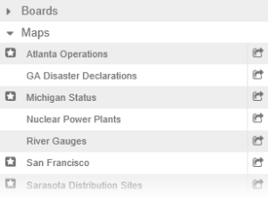
Clicking the name of a map opens it in a new tab within the existing window. Multiple maps can be opened in different tabs. Alternatively, clicking the new window arrow to the right of the map name opens the map in a new window of its own. In this way, you can have a map open as you simultaneously view a board that it is linked to.
You can also access maps from Maps-enabled boards. If a board is enabled with Maps, a Map link or button is likely to appear next to a record entry. Clicking the Map link or button opens a map, jumping directly to the entry's geographical location.
When a map is open, a map icon is shown in the map's tab, readily identifying the tab as a map and not a board.
![]()
Maps Add-on
Maps Add-on expands on the capabilities of the integrated Maps solution. With a modern user interface backed by JavaScript technology, this licensed add-on offers broader support than previous mapping solutions. Capable of running alongside existing mapping solutions, Maps Add-on supports the creation of multiple maps, the use of custom icons, and the management of map layers. Unlike the integrated solution, Maps Add-on allows administrators to fully manage these map layers, live feeds, and map services to create truly custom maps.
Users are also afforded more control with Maps Add-on. Several useful tools are included with the add-on that can help users navigate a map and identify key landmarks. For example, the Find My Location tool pinpoints your location on the map, and the Find Address tool lets you click a point on the map to instantly learn its address or coordinates. You can even measure distances between points or the size of an area, add annotations, and print a display of a map that shows geocoded points.
To inquire about purchasing the Maps Add-on, contact your Client Services Manager.